Iceland Volcano: Seismic Activity Has Increased In Recent Weeks
 A picture taken on June 22 into the one crater that remained active until the end of the eruption that began on May 29. (Photo: Civil Defense)
Geophysical measurements show a trend similar to before the last eruption on the Sundhnúkur crater row
Updated 13 August at 14:00 UTC
Deformation and seismic activity are similar to before the last eruption on the Sundhnúkur crater row
The volume of magma beneath Svartsengi is estimated to be just over 20 million cubic meters
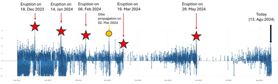
Seismic activity in the area has increased in the last few weeks. About 60-80 earthquakes per day are detected
Hazard assessment is unchanged from last week and is valid until 20 August, barring any developments
Deformation signals and seismic activity show similar patterns as prior to the last eruption on the Sundhnúkur crater row. Model calculations also suggest that the volume of magma beneath Svartsengi is now estimated to be greater than it was prior to the last eruption, which started on 29 May. Prior to the onset, land uplift and magma accumulation continued for two weeks until an eruption started. It can thus be assumed that magma propagation and a volcanic eruption can start at any time, but based on previous occurrences it may be delayed.
Seismic activity in the area has increased in recent weeks and development is similar as before the previous magma propagations and volcanic eruptions. The last seven days have been similar, with about 60-80 earthquakes detected per day in the area between Stóra-Skógfell to Grindavík. Most of the earthquakes are at depths between 2-4 km, the shallowest in the area between Stóra-Skógfell and Sýlingarfell.
 Seismic activity on the Sundhnúkur crater row since 1 December 2023 showing the patterns in seismic activity between eruptions and magma propagations.
Deformation data suggest that land uplift is ongoing but at slower rate. That indicates that magma pressure is increasing beneath Svartsengi. Model calculations estimate that over 20 million cubic metres of magma have been added to the magma reservoir beneath Svartsengi since the last eruption. This is similar to the observed trend which lead to the last magma propagations and volcanic eruptions, as shown in the following graph.
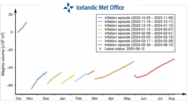 Graph showing the development of magma accumulation and estimated total volume of magma in the magma reservoir beneath Svartsengi from 25 October. Each magma propagation has not exhausted the magma reservoir, and therefore the starting status of magma accumulation beneath Svartsengi will vary in each cycle after November 2023.
Hazard assessment unchanged
The hazard assessment issued by the Icelandic Meteorological Office remains unchanged and is valid until 20 August, barring any developments. The possible scenarios are also unchanged.
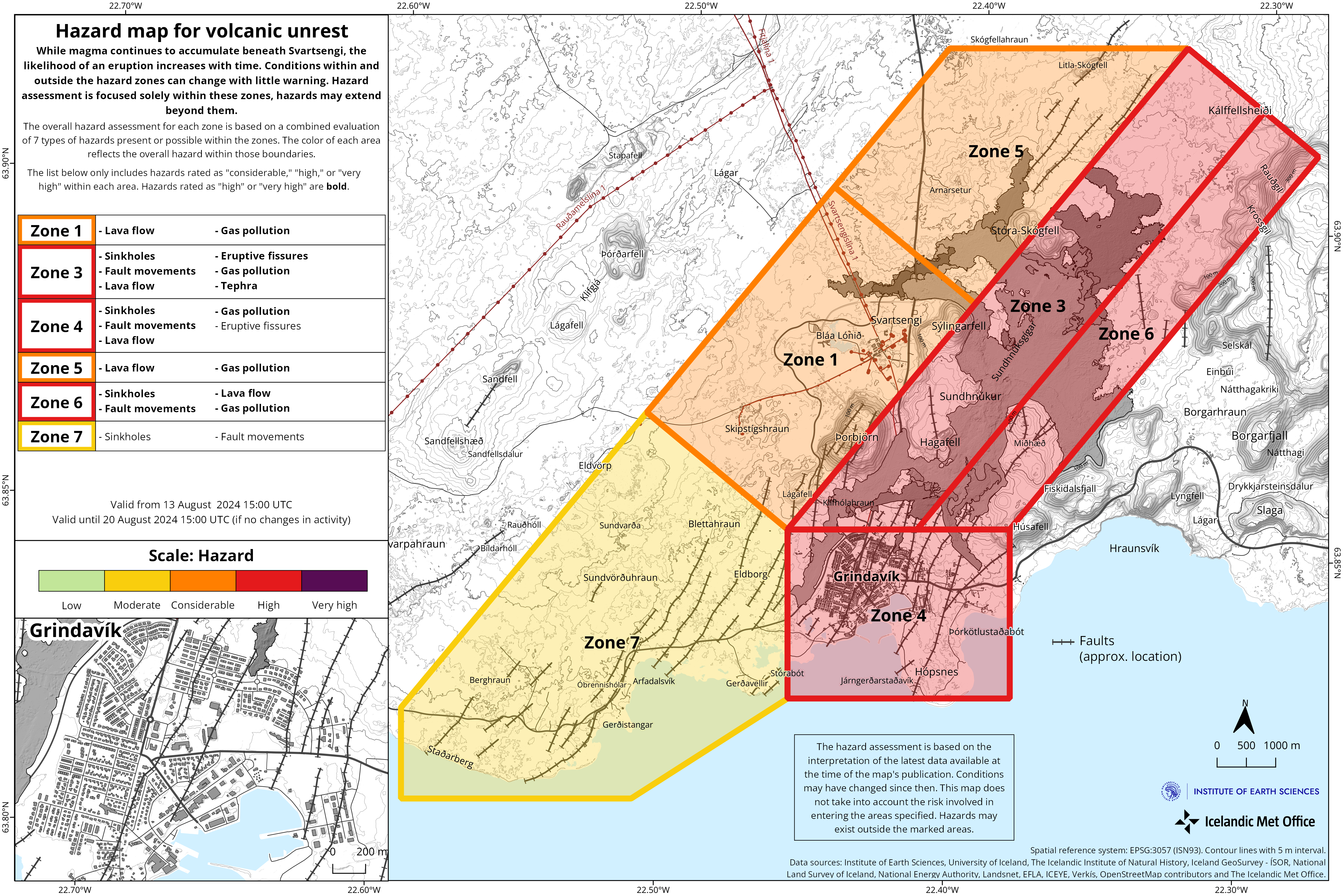
Scenario 1 - Eruption between Stóra-Skógfell and Sundhnúkur (central part of zone 3 on the hazard assessment map). Similar location to eruptions that began on 18 December 2023, 8 February, 16 March, and 29 May 2024.
- The likely precursor is a localized earthquake swarm between Stóra-Skógfell and Sýlingarfell, acceleration in deformation, and pressure changes in boreholes in the area.
- Very short pre-eruption warning time (less than 30 minutes).
- Lava could reach Grindavíkurvegur near Þorbjörn within 1.5 hours and Grindavíkurvegur near Svartsengi within 3 hours.
Scenario 2 - Eruption south of Sundhnúkur, near Hagafell, and extending south towards and potentially within northern Grindavík (southern part of zone 3 on the hazard assessment map and the northern part of zone 4). Similar location to the eruption that began on 14 January 2024.
- The likely precursor is an earthquake swarm starting near Stóra-Skógfell or Sýlingarfell and moving south, with acceleration in deformation, and pressure changes in boreholes in the area.
- The warning interval for an eruption in this area would probably be longer than in scenario 1, but it is uncertain by how much. The length of the warning period depends on how far south the magma must break a pathway to the surface.
- Lava could reach Nesvegur and Suðurstrandarvegur within 1.5 hours. Lava flows could potentially close escape routes on land within about 6 hours.
- In this scenario, lava could reach the sea east of Grindavík within 1.5 to 3 hours. If lava reaches the sea, it could cause localized hazards due to rapid cooling of the lava. Initially, there would be a hazard due to ash and gas formation, primarily hydrochloric acid (HCl). Within a radius of about 500 meters from where the lava enters the sea, conditions would be life-threatening.
- A magma intrusion that reaches south of Hagafell will likely cause significant fault movements in Grindavík.
- There is a possibility that lava could erupt within Grindavík. One scenario is that lava erupting from a vent north of the protective barriers at Grindavík could flow into existing fissures and then re-emerge again within the town limits. Another scenario is the possibility of an eruptive fissure opening within Grindavík. However, in such a situation, it is likely that a fissure would first open north of the town before opening within the town limits.
- Categories
- Date rangeWednesday, August 14, 2024
