


 The volcanic eruption started at Sundhnúks crater row at 21:26 UTC 22 August. This photo is taken one hour after the eruption started and the eruption fracture is estimated approximately 4 km long. Photo: Björn Oddsson/Civil Protection.
Eruption activity in the eruption has been fairly stable over the last few days
Subsidence is still detected at Svartsengi. The outflow of magma from the reservoir is greater than the inflow of magma
Updated 29 August at 18:00 UTC
In the last few days, the activity in the eruption has remained fairly stable.
Lava flows mostly to the northwest but also to the east.
Greater seismic activity post-eruption than in previous eruptions. About 20 earthquakes in the last 24 hours.
The gas distributionforecast today is northwesterly winds, directing gas pollution to the southeast.
The eruption continues in the area northeast of Stóra-Skógfell. The activity has remained fairly stable for the last few days. There are two main lava fountains active which seem quite vigorous. Lava continues to flow mostly to the northwest at a slow rate but also to the east.
 Here we see the development of the lava flow based on ICEye satellite images during the period from August 26th at 22:17 to August 28th at 23:23.
Greater seismic activity is being detected since the onset of the eruption on 22 August than in previous eruptions in the area. That is probably because the eruption is now taking place further north, where more tension is still within the bedrock, whereas tension has been released significantly further south in previous events. About 20 earthquakes were detected in the dyke area for the past 24 hours and 110 earthquakes since Monday, 26 August. They are mostly confined to the volcanically active area.
Land subsidence is still being detected at Svartsengi but at a slower rate. This development is similar to the last eruption. The magma reservoir is believed to be emptying at a higher rate than filling up.
 The graph shows the estimated amount of magma that has accumulated beneath Svartsengi between the volcanic eruptions or magma intrusions that have occured since November 2023.
The gas distribution forecast for 29 August, is northwest 3-8 m/s and gas pollution will move to the southeast. Changing to westerly and southwesterly winds tonight, causing gas to be directed eastwards and northeast over the southwestern part of the country. Tomorrow (Friday), southwesterly winds of 10-15 m/s, causing pollution to be directed north over Vogar on Vatnsleysuströnd. Air quality can be monitored on the Environment Agency's air quality detectors on their website.
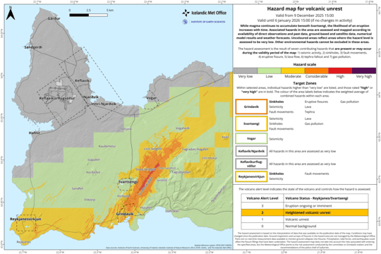
Hazard assessment
The hazard assessment has been updated. The main changes affect Zone 1, which goes from considerable (orange) to moderate (yellow) hazard level. The change is done considering a lower hazard because of lava flow invasion, gas pollution and tephra fallout. A reduced level of gas pollution, originating from the active vent, is assessed also for Zone 4 (Grindavík) and 7 according to gas forecast dispersion in the coming days. The area within the dashed line in Zone 5 represents a probable outline of the development of the lava flow front in a few days.
 (Click on the map to make it larger)

www.malaymail.com/news/world/2026/01/11/bomb-attac…
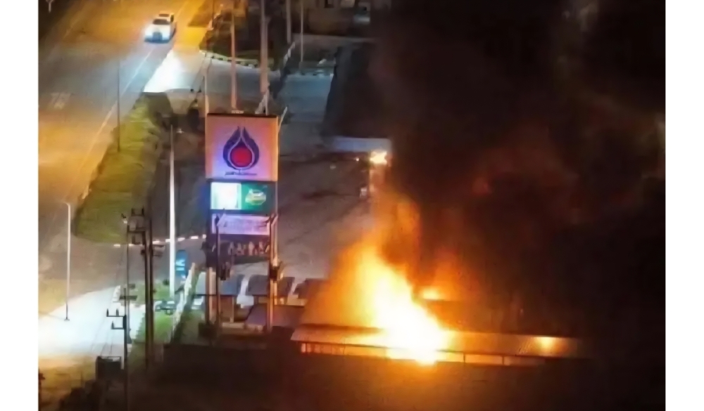
BANGKOK, Jan 11 — A series of late-night bomb attacks targeted 11 PTT petrol stations in Thailand’s southern border provinces of Narathiwat, Pattani and Yala…
www.khaama.com/at-least-eight-refugees-die-37-resc…

At least eight refugees died and 37 were rescued when their boat sank off Badmeli near Izmir, Turkish authorities said on Saturday.
katu.com/news/local/oregon-confirms-first-measles-…

Health officials in Oregon have confirmed the state's first measles cases of 2026, with two people diagnosed in Linn County.
abc11.com/post/measles-north-carolina-state-report…
Measles in North Carolina: State reports 5th case linked to South Carolina surge